
Climb The Machame Route (Mt Kilimanjaro) 2026/27
The Machame route (“Whiskey Route”) is a premier, highly scenic 6-7 day climb on Mount Kilimanjaro known for excellent acclimatization—following “walk high, sleep low” principles—and a high success rate.
Approaching from the south, it traverses diverse ecological zones, including rainforests and the dramatic Barranco Wall, offering spectacular views and a challenging but rewarding, non-technical ascent.
Trip highlights
- Extra day for acclimatization
- High summit success rates (over 95%)
- High guide to client ratio
- Open and private treks available
Mount Kilimanjaro Climb Machame Route. The Machame route, also known as the “Whiskey” route, is the most popular route on Kilimanjaro. Machame’s draw is in its scenic beauty.
However, the trail is considered difficult, steep and challenging, particularly due to its shorter itinerary.
Therefore, this route is better suited for more adventurous folks or those with some high altitude, hiking or backpacking experience.
Mt Kilimanjaro Climb Machame Route
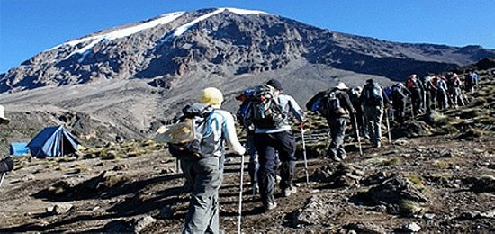
The route approaches Mount Kilimanjaro from the south, beginning with a short drive from Moshi to Machame Gate. The path leads hikers through the rain forest to Shira Plateau. Here, many of Kilimanjaro’s routes converge.
Then the route turns east and traverses underneath Kilimanjaro’s Southern Ice Field on a path known as the Southern Circuit before summiting from Barafu. Descent is made via the Mweka route.
We offer Machame as a seven-day group climb or as a six-day private climb. The six-day variation combines days four and five, going from Barranco Camp to Barafu Camp without staying at Karanga.
Itinerary
- Day 1 Arrival All trekkers need to organise their own flights to Kilimanjaro International Airport (JRO). From JRO we will arrange a private transfer to your hotel. That night or early the next morning you will meet your local representative and have a full pre-climb briefing.
- Transport: Private transfer (0.8 hour, 40 km)
- Accomodation: Hotel
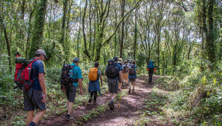
- Day 2 From Machame Gate to Machame Camp Transfer from your hotel to Machame Gate for registration. Our porters prepare and pack our supplies and luggage before we start our ascent along the forest trail to Machame Camp at 3000m. We will stay here overnight.
- Transport: Private transfer (0.8 hour, 30 km)
- Hiking time: 6 – 7 hours
- Ascent: 1200 m
- Max. altitude: 3000 m
- Accomodation: Camping
- Meals included: Breakfast / Lunch / Dinner
Day 3 Machame Camp to Shira Cave Camp After breakfast we start walking, leaving the rainforest behind, and continue our ascent, crossing a small valley and up to a steep rocky ridge, covered with heather.
Mount Kilimanjaro Climb Machame Route
Our route now turns west into a river gorge until we reach Shira Cave Camp. It will be colder tonight than the previous night with temperatures possibly falling below freezing.
- Hiking time: 5 – 6 hours
- Ascent: 850 m
- Max. altitude: 3850 m
- Accomodation: Camping
- Meals included: Breakfast / Lunch / Dinner
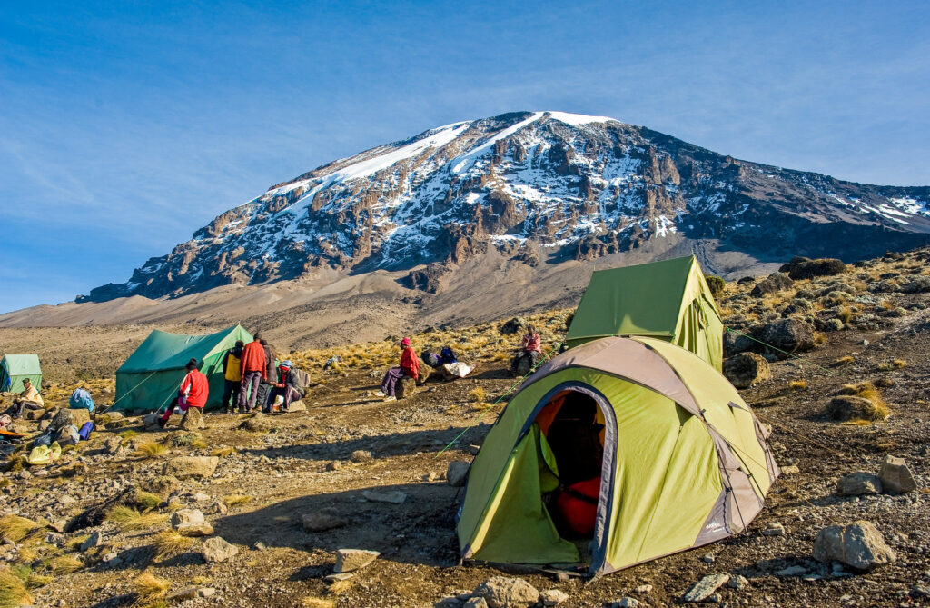
- Day 4 Shira Camp to Barranco Camp via Lava Tower Today we will climb up to 4600m to the base of the Lava Tower for lunch and acclimatisation. This will be our toughest day so far and you may, for the first time, feel the altitude.
- After lunch we will descend again by almost 650m to Barranco Camp, following the ‘walk high, sleep low’ golden rue of acclimatisation. Our descent to Barranco Camp takes about 2 hours and offers great opportunities to take some beautiful photographs of the Western Breach and Breach Wall. The camp is situated in a valley below the Breach and Great Barranco Wall.
- Hiking time: 6 – 7 hours
- Ascent: 750 m
- Descent: 650 m
- Max. altitude: 4600 m
- Accomodation: Camping
- Meals included: Breakfast / Lunch / Dinner
Mount Kilimanjaro Climb Machame Route
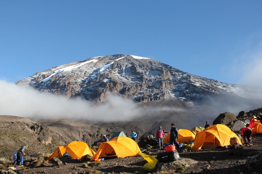
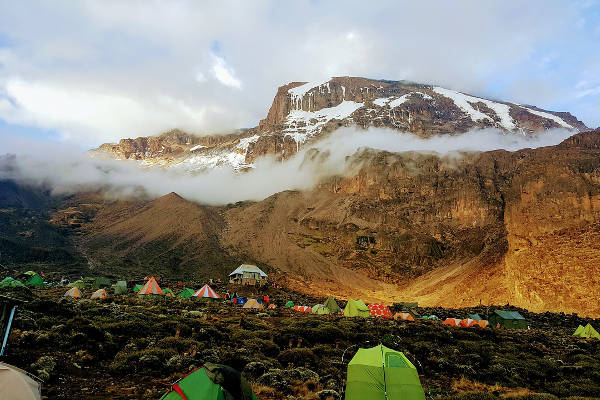
Day 5 From Barranco Camp to Karanga Camp A short, but fun, day starting with a scramble to the top of the Great Barranco Wall. We then traverse over scree to the Karanga Valley (3930m) beneath the icefalls of the Heim, Kersten and Decken Glaciers. We will stay overnight at Karanga campsite.
Hiking time: 4 hours
Ascent: 260 m
Descent: 280 m
Max. altitude: 4210 m
Accomodation: Camping
Meals included: Breakfast / Lunch / Dinner
Day 6 From Karanga Camp to Barafu Camp We leave Karanga campsite behind to meet the junction connecting with the Mweka descent trail. From here we continue up to Barafu Camp. Here we can rest, enjoy dinner, and prepare for the summit day. The camp offers amazing views of the summit and the two peaks of Mawenzi and Kibo.
Hiking time: 4 – 5 hours
Ascent: 465 m
Max. altitude: 4675 m
Accomodation: Camping
Meals included: Breakfast / Lunch / Dinner
Mount Kilimanjaro Climb Machame Route
Day 7 Barafu Camp to Summit to Mweka Camp You will be woken around 23:30 with tea and biscuits. We start our trek to the summit between the Rebman and Ratzel glaciers through heavy scree up to Stella Point on the crater rim.
This is the most mentally and physically challenging part of the trek. At Stella Point (5732m), we will stop for a short rest and hopefully be in time to witness the magnificent sunrise (weather permitting). We are now only an hour away from the summit, Uhuru Peak (5895m), the highest point on Mount Kilimanjaro and the continent of Africa. From the summit, we descend down to Mweka camp site, via Barafu Camp for lunch.
Trekking poles will be needed for the loose scree going down to Mweka Camp (3100m). Later in the evening, we will enjoy our last dinner on the mountain and a well-earned sleep.
Day 8 Mweka Camp to Mweka Gate Your final day on the trek, departing after breakfast we descend a further 1300m to the Mweka Park Gate to pick up your summit certificates from the Park Headquarters. Transfer to your hotel.
Transport: Private transfer (0.5 hour, 17 km)
Hiking time: 3 – 4 hours
Descent: 1300 m
Max. altitude: 3100 m
Accomodation: Hotel
Meals included: Breakfast
Day 9 Departure After a much needed nights rest, we will bid you goodbye. If you have arranged airport transfers with us or a safari / Zanzibar trip, we will collect you in the morning for your onward journey.
Transport: Private transfer (0.8 hour, 40 km)
Meals included: Breakfast
Trip information
Difficulty
The Machame route is considered relatively tough. Depending on your level of fitness, you will be trekking for 6-7 hours nearly every day, at increasingly higher altitude. For the summit ascent, you will need to be prepared for a whopping 12-15 hours on your feet! Climbing up for 6-8 hours and descending back down for 6-7 hours. Arriving in great physical condition and with a tough mental “Kandoo” attitude will be your key to success!
Novice climbers are sometimes nervous about how they will cope with the Great Barranco Wall, but this is just a short scramble that is really not that tricky – you will be helped by your guide every step of the way. One stride around a rock outcrop is the most precarious part you will experience. Thousands of climbers safely travel this route each year, let alone the Kilimanjaro porters carrying heavy loads.

Food & drink
Staying well-fed on your climb is absolutely vital, especially when conditions are such that you might not want to eat or drink as much as you should. Because so many climbers experience a loss of appetite at altitude, our head chef has developed special menu plans that are appealing, healthy, and filled with all the energy you need to make it to the summit. By default, our meals include fresh fruit and vegetables every day. You will have fresh meat for the first part of the trek and on the southern routes where it is feasible we resupply the group at Karanga Camp. As a special reward after your summit ascent, we’ll have an “All Day English Breakfast” ready and waiting for you when you arrive back at Base Camp – just let our cook know how you like your eggs done! And before you leave the mountain, you also get to sample some of the local Tanzanian cuisine such as Njegere and Machalari.
Accommodation
Your full day by day itinerary shows what is included in terms of hotel accommodation and meal basis. All of our pre- and post- climb accommodation is based in Moshi. If you are going on safari prior to your climb, we will have booked you into a hotel in Arusha on arrival to reduce your travel time. Where your hotel basis is B&B, you can usually purchase snacks or meals at the hotel, which can be paid in Tanzanian Shillings, or often in US Dollars. When you arrive at the hotel, take a moment to familiarise yourself with the layout and the procedures in the event of a fire, especially your escape routes and fire exits.
Please be aware that Tanzania is still a third world country and cut offs in both water and electricity supply still happen regularly, and we cannot guarantee that the hotel will have hot showers during your stay. The hotel will help as far as they can, but these outages are outside their control.
We use only the very best high-altitude mountain tents, Mountain Hardwear Trango 3, to ensure you stay warm, dry and comfortable on your Kilimanjaro climb. Please bear in mind, these are proper mountain tents, designed to cope with extreme conditions so don’t expect to be able to stand up and walk around inside! The dry, dusty conditions on Kilimanjaro can play havoc with the zips and they can easily jam. Our guides are armed with WD-40 so just ask them for assistance, rather than trying to force the zip.
Mount Kilimanjaro Climb Machame Route
Your meals will be taken in a separate mess tent where you will be able to sit comfortably, while you relax and chat to your teammates and enjoy the wholesome food that our cook has freshly prepared for you. Inside, you’ll be pleased to find a table (of course) and a proper, comfortable chair with arms. With a full 2 metres of headroom, even the tallest climbers will be able to stretch a bit, and move about without hunching over. They are fully waterproof and regularly withstand the worst weather Kilimanjaro has to offer. A toilet tent is provided with toilet paper.
Transport
We insist on using a high standard of vehicle and driver for all of our transfers. In Tanzania it is not a legal requirement to have seatbelts fitted in the back of vehicles, and while we try to use vehicles that do have rear seatbelts fitted, this cannot always be guaranteed. If you are unhappy about any aspect of the vehicle or the standard of driving, please speak to the driver or our local office immediately. Please note that it is a common occurrence in Tanzania for vehicles to be stopped by the police to check the driver’s documentation and this can seem quite intimidating when you cannot understand what is being spoken. If your vehicle is stopped, this is not a reflection on the state of your vehicle or your driver’s performance.
Luggage
CLIMBING BAG WEIGHT
Kilimanjaro National Park operates an absolutely strict limit of 15kg per porter for your main equipment bag. This limit includes your sleeping bag, even if it is rented from us. This is more than sufficient for your needs on the mountain. Your bag will be weighed before you leave the hotel to start the climb and if it is overweight you will have to take items out and leave them at the hotel. Additional porters can be hired but they cost $25 per day.
PLASTIC BAG BAN
On 1st June 2019, Tanzania introduced a ban on all single-use plastic bags. Please support this fight against plastic by using more sustainable alternatives in your luggage, such as packing cubes and dry bags. Passengers with plastic bags in their luggage may be asked to surrender them on arrival at the airport.
The zip-lock bags required to carry liquids and toiletries in cabin baggage on airplanes will still be permitted.
How do I get there?
For climbers based in the UK or the US, it is best to fly to Kilimanjaro International Airport (JRO). KLM flies to JRO from all of the major UK airports, and many of the larger US international airports as well. UK flights tend to leave early in the morning, transfer at Luchthaven Schiphol, Amsterdam’s main airport, and arrive at JRO late that same evening.
All of our tours begin at a town called Moshi, known as the gateway to Mount Kilimanjaro. Moshi is situated low on the mountain’s south slope, at an altitude of nearly 1000 metres above sea level. Moshi is only 25 miles from Kilimanjaro International Airport by car, and we will arrange transport from the airport to your hotel as part of your trek. Transport is generally available at any time, including the late evening or early morning, and takes approximately three quarters of an hour.
Moshi is an excellent choice for hotel accommodation during your stay, but it does fill up quickly during the peak season, so be sure to reserve your booking with us as early as possible. It is wise to plan a rest day after such a long flight to recover and prepare yourself and your kit for the climb, rather than planning on hitting the mountain the next morning.
Mount Kilimanjaro Climb Machame Route
Some UK climbers choose to fly into Nairobi via Kenyan Airways or British Airways. These flights are only available departing from Heathrow in London.
Climbers arriving in Nairobi generally book a transfer flight to Kilimanjaro international Airport via Precision Air, Air Kenya, Air Tanzania or Ethiopian Airways.
Turkish Airlines, Air Emirates and Qatar also fly into JRO now, but these flights often involve long delays and flights leaving late at night for UK travelers.
However, climbers travelling from the US often report better service and experiences flying with Turkish Airlines, Air Emirates and Qatar, so we do recommend these flights from North America.
Many travelers schedule a beach holiday in exotic Zanzibar to rest up after their climb.
We find the best way to arrange transport for that is to book your return flight out of Dar Es Salaam, then to Zanzibar on an internal flight, and eventually back to Dar Es Salaam for your flight home.
Budget & change
The Tanzanian Shilling is a closed currency so you will not be able to buy this before you arrive. It is advisable to travel with US Dollars, as these are widely accepted.
It is very important that US bills be new (no more than 10 years old), crisp and untorn.
If you want some local currency to purchase snacks or drinks either at your hotel or on the way to the climb then we can take you to an ATM or bank.
There is also a currency exchange as you go through to the Baggage Collection area of the airport. If you are relying on a credit or debit card for emergency funds, make sure you tell your card issuer that you will be using it abroad, or you may find that it won’t work when you really need it.
Please Note that not all hotels can accept card payments so you may need to use an ATM to access funds.
Tips
You will be sent a copy of the tip recommendations and the estimated crew numbers for your group.
At the first camp you will be advised of the final number of crew and their position on the climb.
You may also find on your summit attempt that some of the porters accompany the group to provide additional assistance.
This is an additional task that they carry out in order to support you having the best chance of reaching the summit. Please show your appreciation for any help you receive by tipping these porters directly.
The tipping announcement will take place on the last night on the mountain when all the crew will gather together to celebrate with you. One representative from your group should say a few words of thanks, which will be translated by the lead guide into kiswahili.
Overview
Climb The Machame Route (Mt Kilimanjaro) 2024/25
MACHAME ROUTE KILIMANJARO CLIMB
The most popular route to the summit of Mount Kilimanjaro these days is Machame route, and for good reason. This trail offers stunning views, a reasonable challenge, and plenty of time to acclimate, making it a good choice for those who have a bit of extra time in their schedule.
Machame route has been nicknamed the “Whiskey Route” because it is often perceived as being tougher than Marangu route, which is often referred to as the “Coca-Cola” route. Unlike that trail however, camping is allowed on Machame, which means trekkers will be sleeping in tents all the way to the summit.
Trekkers who take the Machame Route pass several well known Mount Kilimanjaro landmarks while en route, including the famed Lava Tower and Shira Plateau. The route wanders up and down a series of valleys and ridges, which make the walk a bit more strenuous, but rewards hikers with some of the best views on the mountain.
It is for that reason that Machame route is widely considered to be the most scenic of all of the routes up Mount Kilimanjaro, providing unique and varied landscapes to pass through on each and every day. The trail starts on the south side of the mountain, passes underneath the Southern Ice Field and makes its summit approach from the Barafu Camp.
MACHAME ROUTE
The Machame route on Kilimanjaro is a seven day camping route which allows for excellent acclimatization and particularly diverse scenery. It has been called the Whiskey route in the past and nowadays about 35% of all climbers on the mountain use it.
In a matter of days you will climb Kilimanjaro from the equator up to an Arctic zone, moving through grasslands, tropical rainforest, alpine meadows, moorlands and high desert to snow and ice. Each day on this route presents quite a distinct ecosystem to experience, which is one reason it is so popular.
The other reason is that the seven day programme begins on the south west side of the mountain and traverses around to the south east side, enabling you to sleep at the same altitude for three consecutive nights which significantly aids altitude acclimatization. This means that our summit success rate on this route is quite high at around 85%.
We only run seven day trips on Kilimanjaro which is the recommended minimum number of days by all the international mountain associations such as the UIAA (International Climbing and Mountaineering Federation), plus our own assessment of mountain safety. The Machame route could be done in six days by missing out Karanga Valley and going straight to Barafu, but experience tells us that this leads to increased sickness and a much lower summit success rate.
From the start you will be speaking with experienced people who have climbed Kilimanjaro many times, including Gavin Bate who has been leading groups on the mountain regularly since 1994 and is always on hand for advice. We can give you an honest appraisal of the climb, about training for the mountain and what clothing and equipment you will need to buy or rent. This personal service extends to our staff iin Tanzania where AA Tanzania co-ordinator Castro Kapela will meet you and give a team briefing along with our guides.
Climb The Machame Route (Mt Kilimanjaro) 2023/24