
Climbing Mount Kenya Routes
Mount Kenya Natural History
Mount Kenya offers several climbing routes, primarily the popular Sirimon, Chogoria, and Naro Moru, catering to different skill levels, from beginner treks to Point Lenana (trekking peak) to technical ascents of Batian/Nelion (technical peaks).
The Chogoria route known for scenery, Sirimon for gradual ascent, and Naro Moru for speed, with less common options like Burguret, offering quieter experiences, often combined for mountain traverses.
Mt Kenya Climbing Routes
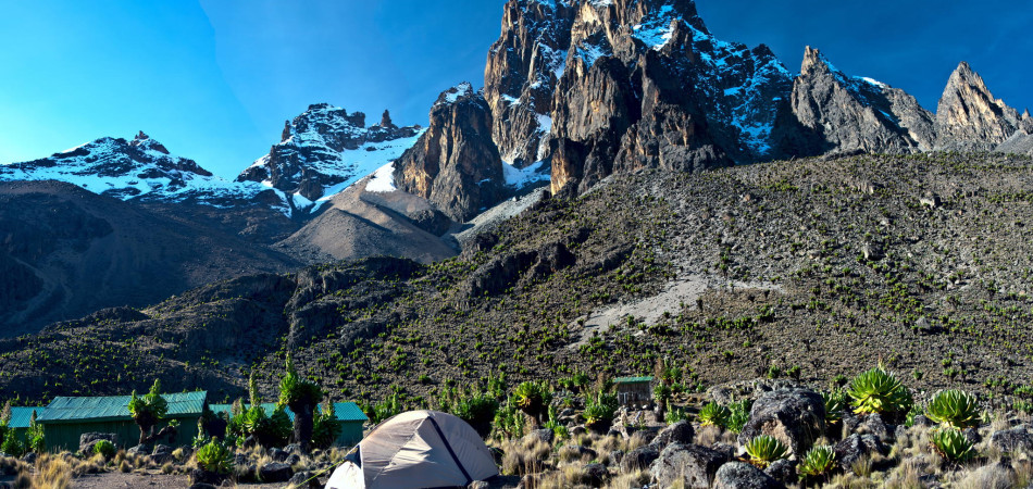
Mount Kenya is Africa’s second-highest mountain at 5,199m (17,058 feet) and the highest of all Kenya Mountains.
Mount Kenya is roughly circular, about 60km across at the 200mm contour, where the steep font hills rise out of the gentler slopes of the centered highlands.
At the center of the massif, the main peaks rise sharply from around 4,500m to the main summit of Batian 5,199m, Nelion 5,188m, and point Lenana 4,985m.
Other major summits on the mountain include Point Piggott 4,957m, Point Dutton 4,885, and Point John 4,883m. Of the three main peaks (Batian, Lenana, and Nelion), point Lenana can be reached by climbing, with the other two being only for technical climbers.
Mount Kenya is the second highest peak in Africa and stands somewhat unjustly in the shadow of its taller neighbor Kilimanjaro, which lies some 320km away in the south and is visible on a clear day.
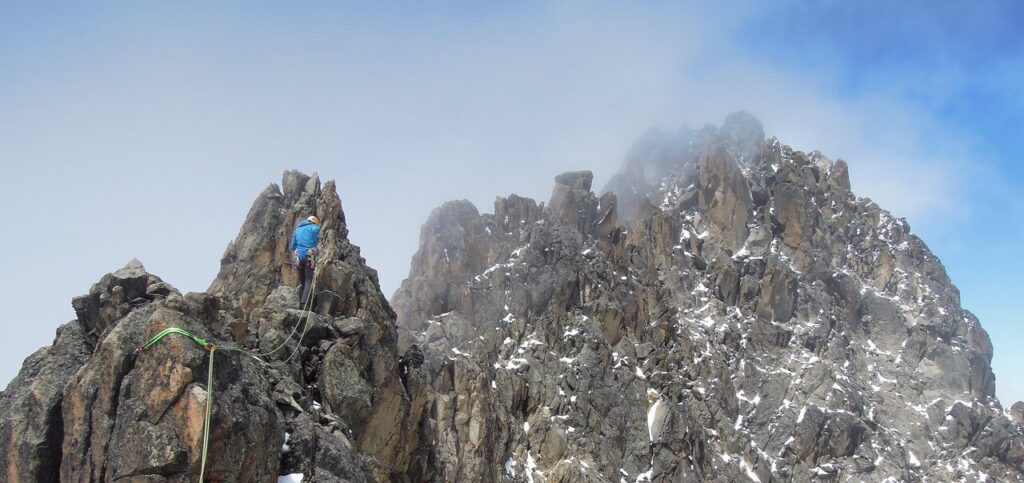
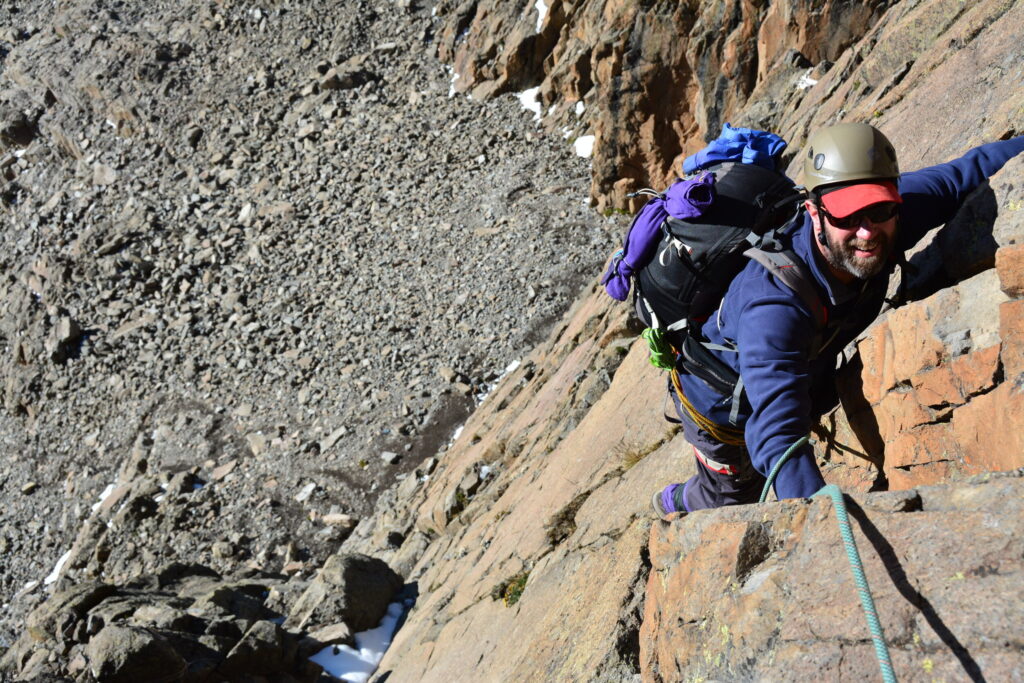
The rock-climbing Mount Kenya can be of variable quality but is at its best high on the mountain where the syenite rock is similar to granite. It is rough, hard, and well-endowed with features.
Mount Kenya Climbing Routes
After the cultivated farmlands on the lower slopes, the trails pass through the rain forest, rich in trees of many species but noticeably camphor, then onto a bamboo zone growing to heights of more than 12m.
The forests are rich in wildlife including elephants, buffalo, and monkeys with even the moor lands offering a long list of mammals including the rock hyrax, the nearest living relative of the elephant.
Mt. Kenya is an ancient volcanic mountain much older than Mt. Kilimanjaro.
What is left is a volcanic plug which erosion has fashioned into the complex jagged outline of the central peaks.
Climbing Mount Kenya and Hiking Mt Kenya routes
Getting to Mount Kenya | Go to Mount Kenya – Group trekking and Private Mount Kenya Trekking and Climbing.
Mount Kenya is approximately 200km north of Nairobi, the capital of Kenya, and is comfortably accessible by road.
Mt Kenya Hiking, Mount Kenya Climbing, Mount Kenya Trekking, and Climbing Africa Mountains.
Others are Climbing Mt Kenya, Walking on Mount Kenya, Mount Kenya trekking route, Naro Moru route, Nanyuki, Sirimon route on Mount Kenya, Shiptons Camp.
Check below summary of the available private and group trekking routes and prices.
Mount Kenya Climbing Routes
Normally the drier seasons are associated with clear, dry weather which can last for many days on end. The best weather is generally in the mornings, and convectional rainfall, if any, tends to come in the mid-afternoon.
Temperatures vary considerably with height and with the time of day. At 3000m, frosts can be encountered at night while day temperatures range from 5 to 15°C.
Nighttime temperatures on the summit are well below freezing.
The south-facing side of Mount Kenya receives more sunshine in the December to March period.
During this time rock climbs are “in-condition” and snow and ice climbs gradually deteriorate. In the June to October period, the north-facing rock climbs and south-facing ice climbs are the best months.
The main routes are likely to be more crowded at this time of the year. If you favor complete solitude over the sunny skies, try going slightly off the peak season.
It’s best to avoid the two rainy seasons from mid-March until June and from late October to the end of December.
Mount Kenya Vegetation
Mount Kenya is home to some fascinating high-altitude alpine vegetation including giant groundsels and lobelias.
In the lower-altitude forest zone, trekkers may come across some rather large and uncompromising African wildlife such as elephants and buffalo.
Fortunately, these are mostly active only at night. Lions, leopards, rock hyrax, various antelope species, and a wide range of other large and small creatures occur in the park.
Mount Kenya Forest Vegetation And Coverage In Percentage:
Bamboo – 10%
Bamboo and Forest Mix – 23%
Forest – 32%
Bushy Forest – 11%
Grassland – 8.5%
Plantation – 9%
Other – 6.5%
Climbing Mt Kenya Map & Map of Mount Kenya hiking routes
Mount Kenya climbing Routes/Itineraries
There are three main routes, which penetrate the forest and the moorland.
The routes are the Naro Moru route, Sirimon route, and Chogoria route. Each of the routes has something different to offer.
The group trek Mount Kenya Climbing Expeditions has offers for the below-hiking routes.
It is possible to combine group hiking Mt. Kenya with Kenya safaris. You must be equipped with the right gears to hike Mt Kenya. This includes warm sleeping bags, and should know the best routes to use.
Remember, it is possible to combine this adventure expedition with a 5-day safari to some of the Kenyan parks.
Climb Mount Kenya Naromoru route – The fastest route to point Lenana but not as scenic as the other two.
It is often overcrowded with many climbers, since it’s the most popular route compared to the Chogoria and Sirimon routes. Trek Mount Kenya climbing routes for groups.
Climbing Mount Kenya and Hiking Mt Kenya routes
Mount Kenya Climbing Chogoria route – The most scenic and interesting of the three main routes on the mountain.
The route passes the enchanting Hall Tarns and looks down sheer cliffs into the spectacular Gorges Valley and onto the beautiful Lake Michaelson.
Climbing Mount Kenya Sirimon route – The least used of the three main routes, but features the most gradual ascent profile and best acclimatization options and above all the most interesting since it’s on the drier side of the mountain.
The route passes through impressive Yellowwood forests in the lower reaches and features abundant wildlife and beautiful alpine scenery higher up.
There are other four climb Mt. Kenya routes up Point Lenana but are least known and used. These are Burguret Route, Timau Route, Meru Route, and Kamweti Route all at different Mt Kenya elevation.
Note: The normal pattern of weather on Mount Kenya is for clear mornings with mist closing in from 10:00 am although this can clear by evening.
Therefore, early morning climb Mt Kenya starts are the order of the day with a 2 am start for the final ascent to point Lenana, if you want to catch the sunrise. Go to Mount Kenya now and experience the majestic sunrise over Mt. Kenya.
Sirimon route Mount Kenya is one of the best routes to use to hike to Lenana Peak.
How long does it take to climb Mount Kenya?
Read below Climbing Mt Kenya itineraries and pricing that might be of help in making your hiking Mt. Kenya plans.
Remember, to attempt the hike, warm sleeping bags are required as it gets really cold up there. Also, technical climbing options available to reach the topmost peaks for the ardent climbers.
Mount Kenya Climbing Routes
If you decide to do technical climbing to the summits of Batian and Nelion peaks, one of the most popular huts from which to start the summit climb is the Austrian Hut or the Top Hut at 4700m.
It is advisable to allow an extra day at Austrian Hut in case the weather does not permit a technical climb on the first attempt. To hit Batian and Nelion Peaks involves technical climbing, and the climbers must be technically fit enough.
Mount Kenya technical climb via the North Face route is usually preferred during the northern hemisphere summer (June to August, through September and early October could be possible).
During these months, the sun will be marginal to the North of the mountain, considering it falls on the Equator. During this time, less snow and ice, making climbing a lot easier with warmer rocks due to the sun.
April, May and October, and/or November falls within the rainy seasons in Kenya. To climb in the December to March season, consider using South East Face summiting Nelion from the south-east face, and Batian through the Gates of Mist.
Mount Kenya Climbing Itineraries and prices:
4 Days Mount Kenya Climbing Naro Moru Route
4 Days Mount Kenya Trekking Sirimon Route
5 Days Mount Kenya Trekking Chogoria Route Down Naro Moru
5 Days Mount Kenya Sirimon Route Down Chogoria
6 Days Hiking Mount Kenya Chogoria Route
6 Days Mount Kenya Sirimon – Naro Moru peak circuit route
Chogoria Route and trek prices
The Gorges Valley is a major feature on the Chogoria Route. This route leads from Chogoria town up to the peaks circuit.
The 32 km (20 miles) stretch from the forest gate to the park gate are often done by vehicle, but it is also possible to walk.
There is much wildlife in the forest, with safari ant columns crossing the track, monkeys in the trees, and the potential for seeing elephants, buffalo, and leopards.
The road is not in good condition, and requires careful driving and walking. Near the park gate, the bamboo zone starts, with grasses growing to 12 m high (40 ft).
Once in the park, the track passes through rosewood forests, with lichens hanging from the branches. At one point the path splits, with the smaller track leading to a path up the nearby Mugi Hill and across to Lake Ellis.
The Temple is a large overhanging buttress overlooking Lake Michaelson, close to Hall Tarns. Near the track, head a small bridge crosses the Nithi stream. Following the stream downriver a few hundred meters (yards) leads to The Gates Waterfall.
The path heads up a ridge above the Gorges Valley, with views to the peaks, Lake Michaelson, The Temple, and across the valley to Delamere and Macmillan Peaks.
Hall Tarns situated right on the path and above The Temple, which is a 300 m (1,000 ft) cliff above Lake Michaelson.
As the path carries on it crosses the flat head of the Nithi River and then the slope steepens. The path splits, heading west to Simba Col, and southwest to Square Tarn.
These are both on the Peak Circuit Route of hiking Mt. Kenya.
Naro Moru Route hike
Vertical bog on Mount Kenya on the Naromoru Route. This route taken by many of the trekkers who try to reach Point Lenana.
It can be ascended in only 3 days and has bunkhouses at each camp, so a tent is not necessary. The terrain is usually good, although one section is called the Vertical Bog.
Go to Mount Kenya climb via Naro Moru route. The track starts in Naro Moru town and heads past the Park Headquarters up the ridge between the Northern and Southern Naromoru Rivers.
At the road-head is the Meteorological Station, to which it is possible to drive in the dry season. The route drops down into the Northern Naro Moru valley to Mackinder’s Camp on the Peak Circuit Path.
In terms of Mt Kenya hiking prices, Naro Moru and Sirimon are the cheapest hiking routes. See individual programs and learn more about affordable Mt Kenya climbing prices.
Sirimon Route Mount Kenya trek
This route starts 15 km (9 miles) east around the Mount Kenya Ring Road from Nanyuki.
The gate is 10 km (6 miles) further along the track, which can be walked or driven by two-wheel drives.
The track climbs up through the forest. On the north side of the mountain, there is no bamboo zone, so the forest gradually turns into moorland covered with giant heather.
The track ends at Old Moses Hut and becomes a path.
This continues up the hill before splitting into two routes. To the left, the least used path goes around the side of the Barrow, to Liki North Hut.
Mount Kenya Climbing Routes
Vegetation becomes sparser, with giant lobelia and groundsels dotted around. Also, the path climbs over a ridge, before rejoining the main path ascending the Mackinder Valley.
Shipton’s Cave found in the rock wall to the left of the steep path just before reaching Shipton’s Camp.
Trek Mount Kenya routes – Mount Kenya Climbing Expeditions

Main Peaks of Mount Kenya: Mt Kenya elevation:
-Batian (5199 m – 17,058 ft)
-Nelion (5188 m – 17,022 ft)
-Point Lenana (4985 m – 16,355 ft)
-Coryndon Peak (4960 m – 16,273 ft)
-Point Pigott (4957 m – 16,266 ft)
-Point Thompson (4955 m – 15,466 ft)
-Point Dutton (4885 m – 16,027 ft)
-Point John (4883 m – 16,016 ft)
-Point Melhuish (4880 m – 16,010 ft)
-Point John Minor (4875 m – 15,990 ft)
-Krapf Rognon (4800 m – 15,740 ft)[17]
-Point Peter (4757 m – 15,607 ft)
-Point Slade (4750 m – 15,580 ft)
-Terere (4714 m – 15,462 ft)
-Sendeyo (4704 m – 15,433 ft)
-Midget Peak (4700 m – 15,420 ft)
-The Hat (4639 m – 15,220 ft)
-Delamere Peak
-Macmillan Peak
Glaciers on Mount Kenya trek
Glaciers on Mount Kenya are retreating rapidly. The Mountain Club of Kenya in Nairobi has photographs showing the mountain when it was first climbed in 1899.
Again more recently, and the retreat of the glaciers is very evident. Descriptions of ascents of several of the peaks advise on the use of crampons, but now there is no ice to be found.
There is no new snow to be found. Even on the Lewis Glacier (the largest of them) in winter, so no new ice will be formed.
The area of glaciers on the mountain measured in the 1980s and recorded as about 0.7 km² (0.25 square miles). This is far smaller than the first observations, made in the 1890s.
Climb Mount Kenya clockwise from the north:
-Northey
-Krapf
-Gregory
-Lewis
-Diamond
-Darwin
-Forel
-Heim
-Tyndall
-Cesar
-Josef
Water streams starting around Mount Kenya
Mount Kenya is the main water catchment area for two large rivers in Kenya.
The two are the Tana River, the largest river in Kenya, and the Ewaso Ng’iro North.
Climbing Mount Kenya and Hiking Mt Kenya routes
The Mount Kenya ecosystem provides water directly for over 2 million people. The streams that start on Mount Kenya are:
-The Sirimon
-The Liki
-The Nanyuki
-Mutonga
-Kithino
-The Nazita
-Thingithu
-The Nitmi
-The Thuchi
-Kathita
-The Nyamindi
-The Sagana
-The Nairobi
-The Naro Moru
-The Burguret
Mount Kenya climbing Information, Mount Kenya facts, trek Mount Kenya joining dates
Mt Kenya climbing itineraries, Mt Kenya Climbing Gears,
Mount Kilimanjaro Climbing Needs, Mount Kenya porters, Climb Mount Kenya, Mount Kenya group hikes, Mount Kenya Guides, Climb Mt. Kenya, Climbing Mt Kenya Routes,
What you need while hiking Mt Kenya Climb and check out facts about Mount Kenya and history and Mount Kenya climbing routes explained.
Mount Kenya Climbing Routes